+1 866 300 9012   contact@measur.ca
SHOPPING CART

No Products in the Cart

TOTAL:
$0.00

Civ Robotics: Revolutionizing Construction Layout

In the evolving landscape of construction layout and road marking, technological advancements are paving the way for increased efficiency and accuracy. One such innovation that is making waves in these industries is Civ Robotics. Designed specifically to cater to the needs of the construction and road marking industries, Civ Robotics is revolutionizing the way these tasks are carried out.

Understanding the Role of Civ Robotics in Construction Layout

Traditionally, construction companies have faced several challenges that hindered their efficiency and accuracy in layout tasks. Manual processes often limited the number of points or markings that could be completed in a day, leading to extended project timelines and increased costs. Moreover, achieving precise measurements can be a constant struggle, especially in rough terrain or adverse weather conditions. Traditional methods may lack the technology necessary to ensure consistent and accurate results, resulting in potential inaccuracies that could compromise project integrity. 

The CivDot and CivDot+ surveyor robots address these traditional challenges head-on, offering higher outputs and laser accuracy while overcoming obstacles associated with rough terrain. CivDot significantly boosts surveyors' productivity by enabling them to mark up to 3,000 points or 16 miles of solid or dash line markings in a single day. This remarkable output allows surveyors to cover more ground efficiently, reducing project timelines and costs. Meanwhile, CivDot+ offers laser accuracy, marking up to 1,200 coordinates per day with an impressive accuracy of 3/100' (8mm). Equipped with a revolutionary 6-axis Inertial Measurement Unit (IMU), CivDot+ ensures precise surveying even on uneven terrain, eliminating accuracy issues associated with traditional methods. Both CivDot and CivDot+ are designed to handle rough terrain effectively, with rugged construction and advanced technology that allow them to navigate challenging environments with ease. By leveraging these innovative solutions, construction professionals can streamline operations, improve efficiency, and deliver superior results in various surveying applications, ultimately driving progress and innovation in the industry.
Sale Off
CivDot
$1.00

Higher Outputs

• Up to 3,000 points or 16 miles of solid or dash line markings in a day, with 1/10' (3cm) accuracy using spray paint
• Compatible with Trimble's R780 GNSS receiver. Leverages IMU based tilt correction
• Great for rough layout for staging piles, topos, grade checking and earth works
Sale Off
CivDot+

Laser accuracy

• Up to 1,200 coordinates/day with 3/100' (8mm) accuracy using a laser point + manual staking
• Tilt correction: Revolutionary 6-axis Inertial Measurement Unit (IMU) for precise surveying on uneven terrain
• Great for high precision layout such as piling, drilling and road markings
$1.00

How Civ Robotics is Revolutionizing Road Marking

Road marking tasks have been labour-intensive, requiring skilled workers to manually paint lines and markings. However, Civ Robotics introduces automated road marking devices that streamline the process and enhance productivity. These devices are capable of accurately applying road markings, eliminating human error and reducing project timelines.

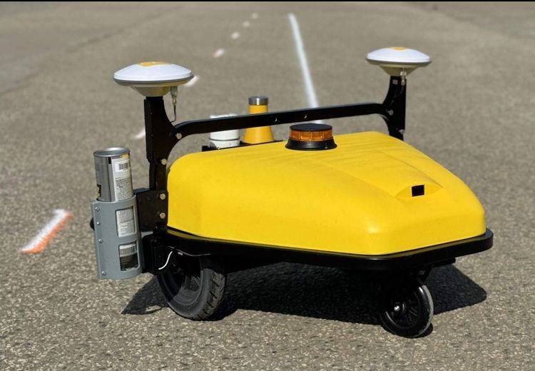
Civ Robotics  CivDash road marking robot is engineered to streamline line laying operations, mitigate risks, and prioritize worker safety, all while delivering exceptional precision and efficiency.
By eliminating the need for manual line laying methods, CivDash empowers contractors to mark roads, parking lots, and airports swiftly and seamlessly. Equipped with remote operations and obstacle detection sensors, CivDash ensures worker safety by minimizing the need for workers to be in close proximity to traffic or hazardous environments. One standout feature of CivDash is its remarkable output capacity, capable of marking up to 25 miles of lines daily, with the option to choose between solid or dashed lines. This high level of productivity accelerates marking operations significantly, reducing project timelines and costs. Moreover, CivDash's sensor fusion technology guarantees precise line work, achieving an accuracy of 1/10', meeting the highest industry standards.

CivDash's compatibility with Trimble's R780 GNSS receiver enhances its efficiency further, leveraging IMU-based tilt correction for faster surveys and seamless integration with top brand base stations for RTK corrections. Additionally, CivDash's lightweight and portable design, weighing only 35 lbs, along with its dedicated space for carrying two additional spray cans, make it the ultimate on-the-go solution for road marking contractors.

Get in touch

Give us a call or drop by anytime, we will answer all enquiries within 24 hours on business days. We will be happy to answer your questions.

Contact Information

We would love to hear from you! Our team is always here to help.

  • +1 866 300 9012

  • contact@measur.ca

  • Vancouver, British Columbia

    Calgary, Alberta

    Mississauga, Ontario

    Montreal, Quebec

Name*:

Phone*:

Email*:

Message:

BACK TO TOP